Apamduööt:Paraná River Floodplain.jpg
Acïn kuerdɛ̈ tɔ̈thïn wär kän lëu bë atïïp tïc.
Paraná_River_Floodplain.jpg (720 × 480 kolook, thëndït de aduötyɔ̈r: 179 KB, MIME kuat: image/jpeg)
| Lëkcäät |
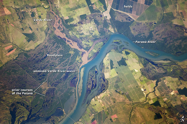
English: Paraná River Floodplain, Brazil
The Paraná River appears as a wide, blue strip with the muddy brown water of the smaller Verde River entering from the northwest (top left). An extensive wetland (dark green) occupies most of the left half of this astronaut photograph, and the floodplain reaches a width of 11 kilometers (about 7 miles). The thin line of a road crossing the floodplain also gives a sense of scale. Above the Paraná-Verde confluence (image center), the floodplain is much narrower. |
|||||
| Aköl | acquired on February 5, 2012 | |||||
| Tënëyök | http://earthobservatory.nasa.gov/IOTD/view.php?id=77444&src=eoa-iotd | |||||
| Agɔ̈t | NASA Astronaut photograph ISS030-E-90012 | |||||
| Kithiɛ̈c (Ke ber wëtmätkën looi) |
|
|||||
| Other versions | See [4] for a larger version |

![[4]](http://eoimages.gsfc.nasa.gov/images/imagerecords/77000/77444/ISS030-E-090012_lrg.jpg)
Käthɛɛr ë makec
Tuenyë në aköl/akɔ̈licic apamduööt ɣoi kecit rɔt nyuɔɔth në akölic.
| Aköl/Akɔ̈lic | Riöpbundït | Thëmthëm | Dului | Këcïjaamic | |
|---|---|---|---|---|---|
| ee mënë | 20:28, 22 Pɛnëdiäk 2012 | | 720 × 480 (179 KB) | Tillman | {{Information |Description ={{en|1=Paraná River Floodplain, Brazil The Paraná River appears as a wide, blue strip with the muddy brown water of the smaller Verde River entering from the northwest (top left). An extensive wetland (dark green) occu... |
Luɔi ë apamduööt
Apam thöökë anuɛ̈tke apamduöötë:
Luui ë yɔ̈rcïduut de pinynhom
Wiki kɔ̈k bɔ̈ looi makec kënë
- Luɔi ba.wikipedia.orgic
- Luɔi bh.wikipedia.orgic
- Luɔi bn.wikipedia.orgic
- Luɔi ca.wikipedia.orgic
- Luɔi en.wikipedia.orgic
- Luɔi eo.wikipedia.orgic
- Luɔi fi.wikipedia.orgic
- Luɔi ja.wikipedia.orgic
- Luɔi sl.wikipedia.orgic
- Luɔi sr.wikipedia.orgic
- Luɔi uk.wikipedia.orgic
- Luɔi vi.wikipedia.orgic
- Luɔi war.wikipedia.orgic
- Luɔi www.wikidata.orgic
- Luɔi zh.wikipedia.orgic